Day 21: Spokane

 Distance traveled: 450.3 km

Cumulative distance: 5,866.9 km

Maximum speed: 120 kph

Moving average: 76 kph

Temperature range: 9.4 - 20 .4

I had a restless sleep but not because of banjo music.  It rained off and on from about midnight plus, somebody drove through the tiny campground about 4:00 am. Hunters, looking to make an early start is my guess.

On the road before 8:00 a.m. Happy to get good, early starts but packing up when everything is wet looses its appeal pretty quickly.  Getting out of the campground, dodging the enormous potholes filled with water was good. The first hour on the road was the last of the real, twisty riding, I'm guessing. The road followed the John Day River North Fork for quite a way; the best part was that in the bottom of the valley, it was out of the wind. 

Once up on the plains, I had a better look at what was in store for me: while there were rain clouds in

every direction, there would be little patches where blue was trying to break through. Not patches of open sky but just where the clouds were thin enough that they looked... bluish. Still raining on me but never really very hard. This went on for all of the morning. I never bothered to put on my rain suit because it just never seemed like it was warranted any time I stopped to take a picture but I did wear rain gloves because there is just no protection from the wind for hands.

Oregon state has massive wind farms. Not that I counted all the wind mills I saw but I stopped a couple of times and took pictures and at one point, counted over fifty just in my view and I had passed several of these groups of windmills. 

I arrived in Spokane just in time for rush hour with no real plan in place, other than to find a motel and visit a Costco and a motorcycle accessories store called Cycle Gear, which listed products from a company called Gerbing, which makes heated accessories for motorcycling. I immediately ended up on the interstate 90 which goes east. Not a lot of point in doing that so I arbitrarily made an exit and found myself in a Home Depot parking lot where there was a lot of space to park the bike and spend some time on my phone looking up motels. This is where having a little OCD would be good. I always hate getting to a place THEN having to decide which place to choose however, I had envisioned riding into town and seeing a long line of motels and then picking one of those. Then I would check in and go look at the two stores I wanted to visit. However, there was no long line, not even a short line of motels. Nothing at all, in fact. The highway just went straight into town and then there was a choice of interstates. I guess I could have sorted this out at Starbucks in Pendleton, where i had morning coffee,

As always, I agonized over the reviews of the motels. Lots of the reviews listed bed bugs or bad neighbourhood so I eventually opted for one of the big chains. I had hoped to take out my tent and related to dry out but that wasn't going to be possible given my bike wouldn't be parked right in front of my door.  Motorcyclers always like to have motels so their beloved bikes can always be close. 

Amazingly, while in the Home Depot parking lot, I see that I am right beside one of three Cycle Gear stores and a block away from Costco! My original thinking was to check into a motel then dump as much stuff as I could and go ride to these destinations however, I had been getting queasy about that given how busy it was driving around. I was just going to have to hope that nobody messed with my stuff, but I did take my tank bag with me into Costco.

I saw this launch ramp in Spokane and I thought it interesting. I thought it must be for Fireball XL 5 but it is actually, much to my disappointment, what looks like a new interstate route through town. What was interesting is that this elevated section was the same at the other end, so they had built the middle section first and they were working on the road to connect to it.


Day 20: Hwy 395, just outside of Dale, Oregon

Distance traveled: 599.8 km

Cumulative distance: 5,414.6 km

Maximum speed: 125 kph

Moving average: 81 kph

Temperature range: 9.6 – 29.4

With yesterday’s debacle behind me, all I could think about was getting out of the motel room. When I dropped off my key, I commented to the desk person that she should tell housekeeping they need to vacuum the room and mop the bathroom. All she could say is “ok, ok” like she wasn’t surprised. That place was a dump.

I was on the road by 8:00 a.m. with no real plan. I started riding down the highway in the direction I had been going when I arrived the prior day however, after not too long, I saw a road sign that said Scenic Route 138 West. Whaaaat? NOT ENOUGH OCD! Maybe I should have planned that a little better, since I wanted to go north, so I turned the bike around and set a course for Hwy 97, the nearest highway running north-south, which was 48 km away.

Down here, 97 is nothing special. It is just a big, highway with 4 lanes and a divider between the northbound lanes and the southbound lanes. I certainly didn’t want to be riding that. But after going by Crater Lake, I was way off my supposed intended route so I needed to make a decision about where I was going to head for the day. The only good thing is that it has sentimental value to it since it would conceivably take me directly home. But boring.

After about an hour of riding north on 97, I finally found a place that made lattes but


unfortunately, it was a drive-through espresso kiosk. Even thought I was warming up at that point, my feet were cold so I was disappointed not to be sitting indoors somewhere, using their Wi-Fi to upload yesterday’s report. Nonetheless, sitting on the curb outside the drive-through, I was able to establish a course of action. I would ride to the town of John Day in central Oregon, then turn north, in the direction of Spokane.

I had to continue north to Bend, Oregon then turn east along Hwy 128 (?). This route took me through


some very beautiful badlands, reminiscent of southern Alberta. Valleys were carved out of the sedimentary basin revealing layers upon layers of what was former sea floor. I hadn’t bothered to mount the GoPro camera on my helmet because, frankly, I am pretty underwhelmed by the pictures it takes. However, I rode through one rocky valley and I regretted not having the camera ready to go so I turned onto another highway in order to  get it set up with a view to going back and then riding it again, filming the ride. Hopefully, before this trip is concluded I’ll have enough bandwidth to get it uploaded.


I filled up with gas at John Day. I finally managed to break 500 km on one tank of gas. I still had lots more in reserve so I could probably have gone 50-100 km more. While there, I spent a few minutes on Google Maps looking for a campground along Hwy 395. I did identify several, though I underestimated the distance to the first, which turned out to be about 90 km. That is how I ended up with such a big day in mileage. In fact, as I was riding to the campground, there was no sign on the highway to indicate that there were two campgrounds off the highway, the first about 3 km of gravel in and the second probably another 10. Even though I had no cell service, Google Maps still showed my position on the map that I had used to see the route and I saw that I had to turn back to an intersection I had just passed a couple of km back. I only need to get to the first one and when I pulled into it, I was happy to see a single person camping in her car and some good ol’ boys at the far end of the campground with a motorhome and a couple of jeep-style 4x4s. My first thought was “Dueling Banjos.” However, a few of them have said ‘hello’ to me as they have gone by but they seem remarkably well behaved given the circumstances. I did visit with the gal when I had picked a spot and despite the fact that she was quite chatty, she clearly didn’t want any company. As I had gone by her campsite, I had 


some challenge navigating the mud holes in front of her spot, which must have been from a good rain last night, which would not surprise me since it rained a fair amount on me yesterday. I said to her that I half expected to dump the bike in front of her but for a change, that didn’t happen.

As I had been riding towards the campground, I was anticipating a nice, cooked dinner of backpacker’s food however, I saw that unlike other state campgrounds, there were no bear bins. This gave me some discomfort because panniers don’t stop bears, as we learned once. So I abandoned the idea of cooking any food. But one of the good ol’ boys walked by me – he was out bow hunting for deer (he didn’t have an elk tag) and he told me the only sign of bears he had seen around there was some old, dried bear scat so he didn’t seem at all concerned. I relaxed, but still didn’t cook anything, relying on the snacks I had with me.


Day 19: Diamond Lake, just outside of Crater Lake, Oregon


Distance traveled: 546.3 km

Cumulative distance: 4,814.8 km

Maximum speed: 125 kph

Moving average: 79 kph

Temperature range: 5.4 – 20.4

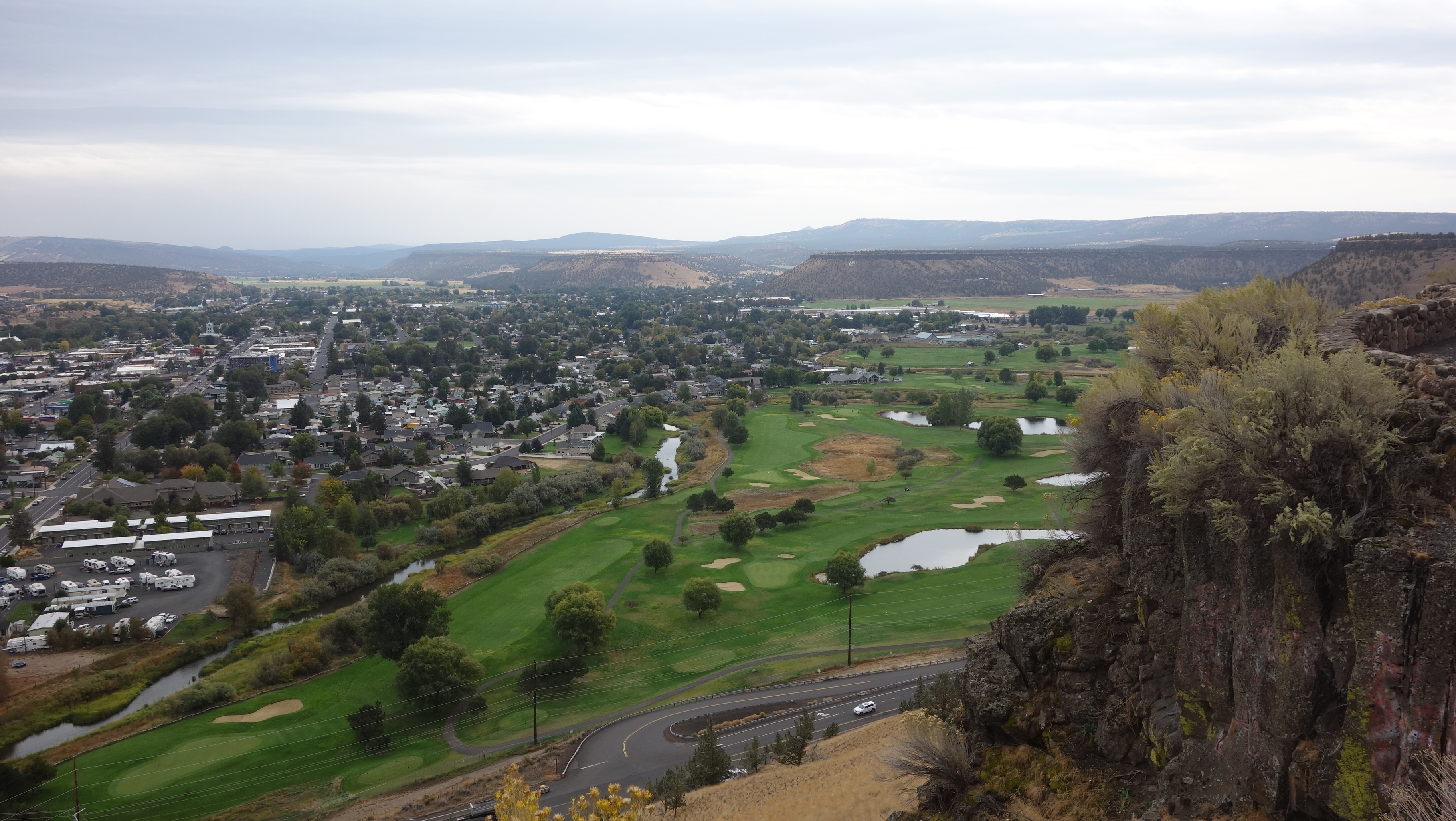
All over are these old cinder cones.

Woke up early, so packed early and on the road early. 7:10 am and I was out of Red Bluff. It’s Sunday morning and minimal traffic and the first roads are back roads to get me to Hwy 44, which will lead me north, connect to Hwy 97, The Volcanic Scenic Byway. Ironically, this is the same Hwy 97 that passes by our house by 2 km. We can see it from our balcony. Maybe Mt. Boucherie is part of the same tectonics that caused all the volcanoes down in Oregon. We have all heard about Mt. St. Helens. Same dastardly chain. And there are little cinder cones everywhere.

After an hour of riding, stopped for gas and I was behind another vehicle at the pump so I thought I was obliged to take the one available pump. Turns out, that was not a puddle of water on the ground in front of the pump but oil. I didn’t realize it until I was getting on the bike after filling up and my foot slipped off the peg. I grabbed a large wad of paper towels and wiped off my boots and peg. Fortunately, my bike tires were not smeared with it but I nearly had a mishap getting the bike off the stand and it made me nervous for the first few kilometres. I was happy to have to stop the bike and put on another layer as the temperature was dropping down to single digits. I walked around in the gravel and the grass to try to get a little more friction on the bottom of my boots and I made a point of riding around in the gravel on the side of the road in hopes of getting any oil on the tires off.

I rode till about 11:00 am before stopping in McCloud for breakfast. It was a popular spot but I am sad to say that coffee was not their strong suit. There was actually an espresso shop in the same building but they only served a few baked items and I was looking for something more substantial. I had contemplated not drinking any more coffee at the restaurant and then going to the espresso shop to get a latte but when I wasn’t looking, my coffee cup got filled at the restaurant. Aside from which, two pancakes, two eggs and two house-made sausage patties pretty much precluded me from consuming anything more.

I later rode through the town of Mt. Shasta, on the doorstep of the retired volcano Mt. Shasta. The town reminded me of what I saw in Nevada City: little shops of occult stuff, tarot cards and little restaurants and coffee bars.


The mountain itself is quite dramatic and I rode an extra several kms trying to get a good picture, though frequently, there were obstructions in the way. Usually power lines. I offer you what I have.

I had the distinction of riding through Weed, just north of Mt. Shasta. When I saw road mileage signs for Weed, I wondered if it was some kind of dispensary or... a joke. Well, I get to weed and there are stores selling t-shirts that say "I heart Weed!" But the best thing was seeing a police officer with a car pulled over and the side of the cruiser said "Weed Police". You can't make this stuff up.

Shortly after riding through Mt. Shasta, the winds picked up with a vengeance. At times I would ride in the right hand side of the lane in order to avoid being blown into the oncoming traffic. Along with the wind eventually came rain. Lightly at first and since I basically achieved my target area of Chiloquin mid-afternoon, I thought I may as well just keep riding because I sure wasn’t going to sit around in a campground in this weather. On a lark, I turned off Hwy 97 to ride up to Crater Lake.

Nan and I had driven by it a long time ago. I don’t think we had even been married a year at that point and I thought it would be nice to see it again. In the rain this time. And the wind, as it turned out.

There is actually a little traffic in the park, despite the weather. And notwithstanding, there are actually


some pretty good views. I was riding around the East Rim, which offered some pretty amazing views but again, the winds were horrendous. At one lookout, I stopped and parked the bike to get off and take some pictures. Let me just say after my little mishap last October where the bike tipped over waiting for a ferry, I am always really conscious of the angle of the bike when I park and I will always go out of my way to make sure that the bike is leaning sufficiently on its stand. In this case, it didn’t matter. I took some pictures and when I turned around, I saw the bike laying on its right side. Down again. I cursed. I ran over and tried to grip it but the dry bags prevented me from getting a good grip so I ripped them out of their straps, got a good grip on the pillion’s handle and with my back to the bike, hoisted it upright. With the panniers, top case packed and the tank bag, the bike would be approaching 800 lbs. Nothing like a little adrenalin to give a boost. Because the kickstand was already down I didn’t have to worry about pushing the bike over the other side. Another mirror housing obliterated. But the mirror survived. This time, I had the wherewithal to keep all the housing pieces. I moved the bike to be better positioned against the wind and got off to collect the dry bags and water bottles etc. and DOWN AGAIN. This time, though, the top case is open because I was putting bits of


mirror housing in there so now that stuff is flying all over the place in the wind. The only GOOD thing is that the wind is swirling as opposed to just blowing over the bluff. But I had to pick up the bike again. The second time, it was a little harder. I was worried my feet were going to slip out from under me but fortunately, that did not happen. My “winter” riding gloves, my jacket, bags from the top case, they are flying all over the place and once I got the bike up and moved again, I was running around trying to grab this stuff before it flew over the rock railing and down 1000 feet into the lake. It would have looked comical to an outside observer but it was a humiliating experience. I have heart palpitations just writing this.  If you can believe it, I still stopped for a couple of more pictures but without getting off the bike.

I'll just let you speculate what that is about.
"Always an adventure".


Once out of the park, I was looking for gas. I stopped at a little out-of-the-way gas station and the owner was asking me if I was camping. “Not in this weather” (or humiliation), I remarked. He suggested I drive a little further down his side road to the Daimond Lake “Resort” (my emphasis). That’s what it is called. “Resort”. I think it must be a resort for hillbillies. I sincerely apologize to any hillbillies that might be reading this because I mean no offense. The room clearly hasn’t been vacuumed in some time – I did NOT eat popcorn in here, walls are dirty and the doorknob is barely hanging onto the door. As always, I check for bedbugs and even though there is no bedbug mattress cover, there are no signs of the little varmints. Nonetheless, I keep all my clothing in Ziploc-styled bags in order to compress the items and they are staying in the bags tonight zipped tight. On top of the stainless steel pedestal table.


Epilogue: more photos

  Week 1 Beach at Fort Stevens. Surfers at Fort Stevens. Nuts! Fort Stevens military lookout. Random small town buildings. Crab fishermen. S...