Day 4: South of Forks, Washington

 Distance traveled: 189.4 km

Cumulative distance: 935.3

Maximum Speed: 114 kph

Moving average: 60 kph

Temperature range: 13.4 -27.0

I had planned to disparage my next door neighbours for all their talk about getting up at 4: 00 am to go fishing because when I got up at 5:20 there was no sign of activity. Nor was there any time after that up until the time when I left the campground so I guess they were good to their word. I'm surprised I didn't hear them but I certainly heard other campers at 5:20! And since I was awake, I didn't see much point in trying to go back to sleep because the campground got very busy in short order. Even at that hour, there was an endless stream of people launching their boats or getting their trucks parked or trailers or whatever. 

This place isn't a typical "tourist" place, it is one devoted to campers who like to fish.  The place smells pretty strongly of fish because the scraps are thrown into the water right there, camp sites are only a few feet apart so motor homes and trailers are packed in tight but nobody seems to mind. Everybody there is doing the same thing and enjoying themselves. I reiterate I was invited to the pot-luck tonight so Sally and her family obviously know people around. People there are do-it-yourselves-fish-charterers and it is clear that everybody is there for the same thing. From almost the moment I was up, there was a steady stream of boats launching or going out to sea. I could sometimes see three or four boats at a time heading out.


My new best friend Sally had offered me her park pass to visit Cape Flattery up past Neah Bay. I had thought about it the night before but this morning, since I was up early, it just made sense to get up there in the morning light. First however, I had to get the camping gear a bit drier and I then needed to pack up. It was a vigorous start to the morning with the temperature at a balmy 6 degrees and everything soaked like it had just been in a monsoon. It was clear all night and the dew showed it.

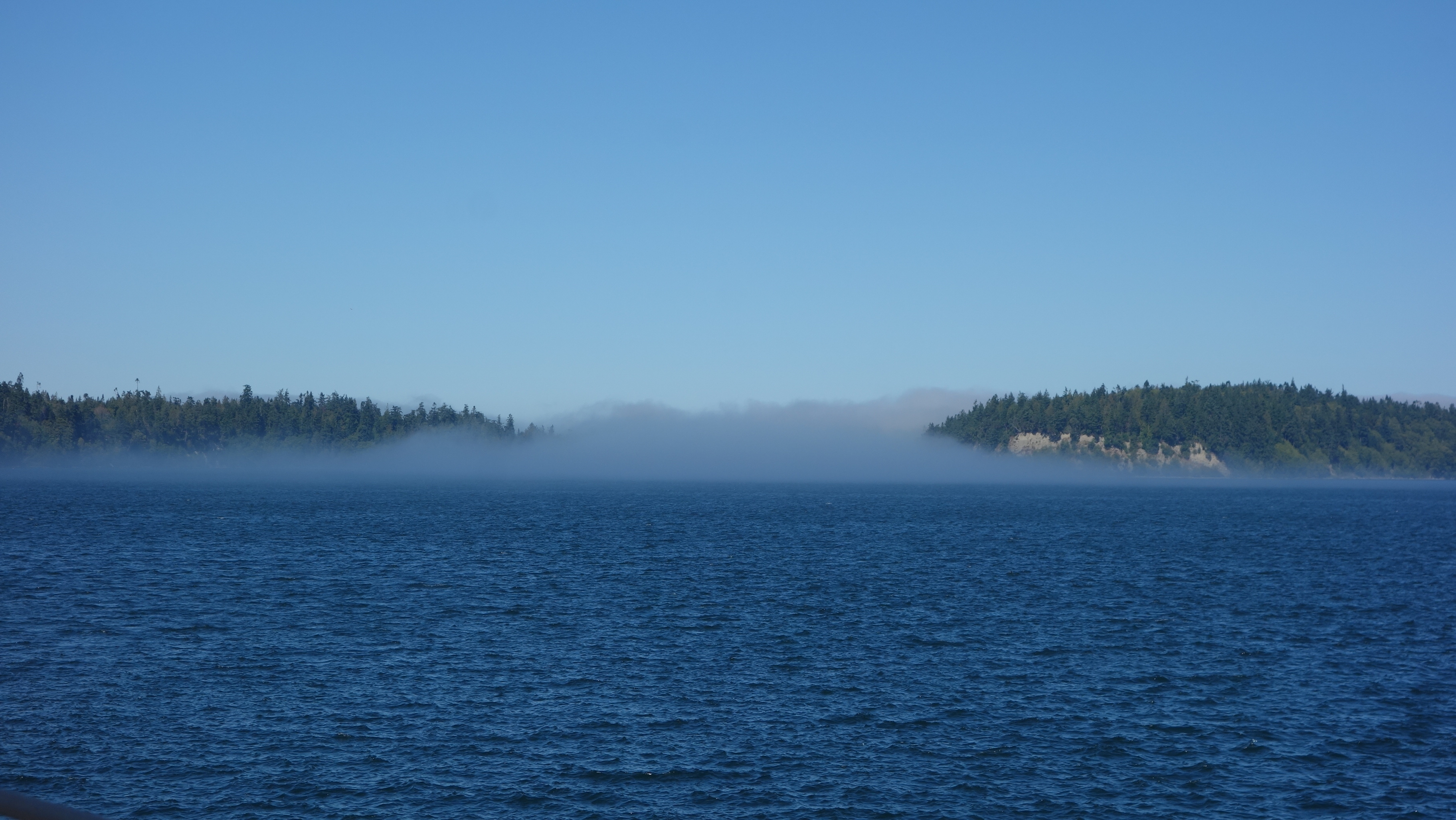
It was a pleasant ride up to Neah Bay as there were many fishing boats out as well as some tugs pulling barges, freighters and a couple of cruise ships all going through the Juan de Fuca Straight. Foggy in places but not so foggy that my view or vision was at all impaired.
The park is at the end of the world. I was told twice that Flattery Point is the highest latitude part of the continental U.S. A. Somebody can fact check that but it looks likely as it is right around the 49th parallel.

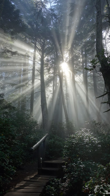
Sally's park pass got me an easy admission and when I got to the end of the road and parking lot, I disrobed my moto gear, extruded my tank bag backpack straps and hiked the short distance through rain forest to the end of the earth, about 15 minutes.

I was treated to the following scene on the way down. One of the most beautiful I have seen.
The view of the lighthouse at the point is the view that people are ostensibly coming to see but I think these other scenes are at least comparable.


I spent an hour at the park. It would be great to spend a few hours watching the changing light. I did have the good fortune to be there as the fog was lifting.

I can't believe my good luck at having met Sally because it is unlikely I would have made the trip out to the point. This was as good as it gets. I saw her briefly when I went back to the campground and to her place to deposit the park pass in the agreed upon spot. I had also dropped off my two dry bags in her yard and she was quickly off on another errand (of mercy, no doubt) but after she left and as I was packing the bike, the rest of her family returned from fishing. Her brother showed me pictures he had taken that morning of a pod of humpback whales that had visited them while fishing. The whales had come as close as about 20 feet. It was quite spectacular. 


I hope this does not become a pattern but by about 3:30 pm I was looking for a camp spot without much luck. I visited a couple of state camp grounds that were full, turned off the highway to a couple of others but it was unclear if they were five km or fifty km away so turned back, then decided to investigate a promising spot off the highway. It looked suitable, flat, not too rocky and trees around to hang food. However, I also discovered, as I walked around inspecting the prospects, a large pile of reasonably fresh bear scat (probably within the last 24 hours) as well as plenty of coyote poo.  I guess I am no longer the adventurer I once was.

What I did find worked out quite well. Driving down highway 101, I spotted a state sign that said "hostel 1/4 mile". As I passed the hostel, I noticed it had a nice big yard so I decided I should check it out and ask the warden if I could camp there.  As it turns out, the hostel is a person's home and there is no answer at the door. However, it DOES say hostel on the highway and there is an old "park" sign, so I figure it is as good a prospect as any and hopefully, when someone returns, they are not packing and run me off.
I set up my camp, cook some dinner and I am washing the utensils out when the homeowner Jimmy returns. He pulls into the yard and I saunter over. He does not look in any way fussed, though I did feel a little like an interloper. However, he quickly explains that this is not the first time he has come home to find someone in his yard and it is all good. Payment is by donation with the recommended amount $10. He tells me he will leave the door to the house open all night so I can use the bathroom.

OK, one last point before I go to bed. I don't know what it is about riding in Washington but my bike seems to have bad luck here. I had a tip-over in the gravel at the campground and obliterated my left side mirror so I will be looking for a bike Band-Aid on Monday. I had a tip-over last October in Washington as well. 

Day 3: Clallam Bay


Day 3: Clallam Bay, Washington (I can see Canada across the Juan de Fuca Straight!

Distance traveled: 233.9 km

Cumulative distance: 750.4 km

Maximum speed: 112 kph

Moving average: 61 kph

Temperature range: 14.0 – 25.8 but at times, when it was the low 20s, it felt 10 degrees cooler.

Editor’s note: Somebody said “hello” to Rob in the comments. To whomever, Rob says “hello” back!

This morning, despite being relatively organized, it was a 10:30 am departure from Rob’s place. We spent the morning visiting and discussing the best way for me to get to the Edmond – Kington Ferry and whether or not his cat was a male or female. I had picked up the ferry schedule and I was targeting the noon sailing and I didn’t foresee an issue as it really wasn’t terribly far; maybe 30 km through Seattle traffic so I figured I was safe to skip the interstate… and stay safe.

To my surprise, it was surprisingly warm at 21 degrees after it had been only 13 a few hours before. I was dressed for a cool ride with jeans and a Canadian Olympic Motorcycle Touring Team jacket. I enjoyed a fairly civil ride through Seattle side streets and at one point, again I was riding alongside the interstate but I wasn’t feeling too anxious. However, at about 11:30 I checked the anticipated arrival time at the ferry and the GPS forecast 11:50 am. I wasn’t going to make it. Nonetheless, I remained pretty stress free about it all. It would mean an extra hour wait so I started to consider one of my other tasks, which has been to pick up a domestic SIM card for my phone. I was bound and determined not to get bent out of shape about the time and just allow myself to take it as it comes. But I didn’t see a suitable place to get the SIM card, so before I knew it, I was arriving at the ferry terminal LINE about high noon. This looked gross, like a two sailing wait, so I dutifully got in line and turned the bike off. Within about a minute, the driver of the car behind me was standing beside my bike and helpfully told me that motorcycles don’t need to wait in line, I could just drive to the front of the line and buy my ticket. Suddenly, the departing ferry was becoming more of a possibility so I raced ahead, hoping I understood his directions correctly.

I rode up to the gate and the attendant told me I had to go inside the neighbouring building to buy a ticket so I left my bike parked in the motorcycle lane, raced inside and looked frantically around for the place to buy the ticket. There were two unattended machines there and I thought, “great, now I have to figure these out in a hurry” but then I spotted a wicket at the far end of the terminal. I hurried down to the wicket and the attendant deducted US $9.20 from my retirement savings and told me I was going to make it.

By the time I got back to my bike, cars were already loading so I wasn’t sure if I was going to be allowed but I loaded last and was sent up a ramp that would lead me to the front of the ferry. I guess all the cars in line were waiting for a different ferry, likely Whitby Island. Unlike BC Ferries, there were no signs indicating for which ferry cars should line up. Or at least, that I could see. Departure time ended up being about 12:20 or even later so I am not sure if it was late or I was just wrong about the schedule but it all worked out.

I just stayed on the car deck and tended to my electronics. Making sure I had a good battery in the camera and that I had the correct things charging. Honestly, I am not OCD about the electronics, I am just making up for not having my photographer along.

There was a fair amount of fog about this morning. Despite it being sunny in Seattle, there was fog all the way across Puget Sound and the ferry’s horn was frequently sounding to warn other craft that we were likely way bigger and they would be better off getting out of our way.

After a respectable crossing time, which I believe was accelerated due to the late departure, I was crossing into Kingston and once again, looking for a suitable place to buy a SIM card, in part, because I had no other real destination in mind. I wanted to go through Port Angeles but other than that, I really had no idea where I was going.

I was a little disappointed that there was not much beach front to see once I had been through Kingston and it was fairly straight forward riding until I got to Port Angeles, which, as it turns out, was big enough to have an AT&T store. So if you have been trying to phone me, don’t bother because I have a different phone number for the trip. However, I’ll save about $200 from the Bell Media thieves.

After Port Angeles, the road got a little more interesting and when I passed an intersection of Highway 101, upon which I was traveling and Highway 112, I stopped the bike and looked at Google Maps just to double check where 112 went and on a lark, turned the bike around and went down 112. Immediately, the road became much more interesting so I was promptly rewarded.

As the afternoon wore on, (I had exited Port Angeles about 2:30 pm or so) it was becoming increasingly clear that this was not going to be a big mileage day. In fact, by about 3:50 pm, the sun was getting lower and the thermometer was doing the same. Along 112, the road definitely hugs the coastline more, so I started thinking about just camping rough – on a beach or on a logging road, both of which were in plentiful supply. The only problem with that is that I would not have any water to cook some dinner and it would result in a short meal of protein bars and roasted almonds. Unless I found clams and cooked them in sea water. With a side of urchin roe.

Then I happened upon an intersection and I stopped the bike to look up where the respective roads went and what prospects I might have for camping. Turning left would take me back to the famed Highway 101, which will ultimately take me down the coast, and right would be to No Man’s Land BUT, also Sam’s Trailer Park. I bet THAT would be a good place to camp and it is probably on the water.

Well no, it does NOT look like a good place to camp. It looks like a homeless camp so I kept going a little further and into Clallam Bay. There is a sign that says Visitor Information and I figure it is about time to ask for some guidance. However, it is not clear where the Visitor Information is located so I go into the co-op store there and a kindly elderly (“older than me”) lady working in the store tells me that the county hasn’t bothered to move the visitor information sign and the store likes it that way because more people come inside.

I ask about camping and the store clerk is a wealth of information, pulls out a local map and points out where I could camp and even which beaches would be suitable. Then a shopper offers her suggestion of the place SHE is camping so I think that sounds pretty good. There are both giving me directions at the same time and I am not sure they are giving me the directions to the same place or different places so the shopper offers to lead me there. I carry her groceries to her car for her and first, she drives down the road in the opposite direction so that I can see a trail to a nice beach then she leads me to her campground, drives me through a “loop” in the “campground” and ends at the place where the owners of the campground are going to put a serious strain on my retirement finances. I’m thinking at this point the homeless camp is looking pretty enticing. My new found friend, Sally instructs me to visit Neah Point and be sure to hike down to the beach. She has a park pass and offers to lend it to me because it would otherwise cost me US $25. It’s 5:30 and she makes it sound so good I contemplate getting set up in my THIRTY FIVE DOLLAT CAMPSITE (see attached picture) and going out to the point before having dinner but I quickly realize that that would be foolhardy since it would likely be dark by the time I get back.

The Co-op store where Howie met Sally.
With my tent site established and dinner consumed, I wonder down to Sally’s camper. She and her husband Ernie camp here all summer then go down to Arizona and camp there all winter. He is a keen fisherman. She is not. They have other family there in attendance but it is not clear to me if they are all on the same schedule but they are a nice family. They even offered me clam chowder and to come back tomorrow night for the neighbourhood pot luck. I decline because I am a man on a mission.

As I finish this off tonight, the fishermen and women are all tucked in their beds. It is 9:20 pm and the people across the road have shut off their music. My next door neighbour, all of 5 feet away, tells me they will be up at 4:00 a.m. to head out to fish for Coho salmon tomorrow. I’ll try to sleep in.

BTW, it’s 11 degrees our here. Pictures will have to come Saturday morning since my computer was too tired to go on.


Camping location.


Elk in a farmer's field.


Puget Sound

 No riding today. 

My high school buddy and host Rob and I took a drive to his recreational property around Puget Sound to meet with the plumber working on his house cabin. 181 km, it was a 2 1/4 hour drive through gnarly 10 lane traffic.


We crossed the Tacoma Narrows Bridge, a double suspension bridge over Puget Sound. This is the site of the infamous Galloping Gertie, the name of the prior bridge that would bounce wildly in certain wind conditions. That bridge had a bad end months after it opened in 1940, which resulted in the construction of a new, then subsequent additional bridge. 

A short while later, we crossed the Hood Canal Floating Bridge, which is in fact a draw bridge designed to allow Trident nuclear powered submarines through Hood Canal for practice manoeuvres.  Rob's cabin is resident on Hood Canal and he described how, on occasion, submarines and sometimes war ships will be engaged in naval games just off his property and he has a front row seat to see the action.

Rob is the most easy going person you could hope to meet. He rarely worries about anything (a benefit of retirement) and doesn't feel at all bad about taking his time. We have been friends since grade 10, celebrating 49 years of friendship.


We were drinking then, too!

Back on the road tomorrow (Thursday).


That'sDay 1: Bellevue

 Day 1

Distance: 516.5 km

Cumulative distance: Duh!

Temperature range: 13.2 - 26.2

Maximum speed: 137 kph

Moving average: 80 kph

My weight at the start: 155 lbs./70.5 kg


That's your intrepid reporter getting ready for departure this morning. 

I was on the road about 8:45. I realistically didn't expect to get going at 7:30, which is what I had "planned" in advance. I was up at about 7:00 a.m. and had to have coffee with my trophy bride before I could consider anything else. Finished off the peach cobbler for breakfast and then had a send-off from some gals on my street: Nan, Bojana and Senka. It was a bit teary as there3 was a little bit of sobbing but once I was on the road, they couldn't see my puffy eyes!

It was fresh going over the Connector and I was thankful for Stan's ST Repair Emporium out of Edmonton for helping me diagnose my failing heated grips, one of the electrical upgrades last week. I recently wrote that the Connector, which is the highway that connects the Okanagan with the Coquihalla and the outside world, is a very fast highway and easily overlooked as a worthy ride because it has a nice view but because it is so fast, nobody is looking around. I've done it a hundred times so, no, I was not looking around but it was a lovely morning so I did stop at the summit (1700 metres and the 13.2 degrees noted above) and snapped this shot of the wind turbines.  I could have used the power generated here when we were without last weekend.

I zoomed over the Coquihalla which was good riding today. Pleasant temperature in the low 20s and pretty good traffic until after Hope. Past there is was the usual congestion and the smell of pig farms. I double checked my route at Abbotsford and turned down Hwy 11 around noon to the Sumas border crossing where I quickly bypassed the line by going through the Nexus lane, which did not have one car. The border guard was vaguely disinterested and asked me what I was packin'. Wine I told him. No weapons. 


On the US side, I found myself in the Nooksack (do you think they are embarrassed by that name? I blushed!) Valley on a windy, no-shoulder four line road. Not busy as it primarily serviced small berry farms, primarily raspberries, blueberries and a few flower farms but significantly better than the alternative: riding further west and joining Interstate 5.  I kept an eye out for a place where I could have a little picnic to eat the sandwich that Nan prepared for me and I saw a sign for Whatcom Lake. I thought "that sounds promising" so I slammed on the brakes, did a sharp turn and rode about 15 km to finally get to the lake. I could see the odd little path the led from the road to the lake but no real place to sit and enjoy the modest view. I ended up just parking on the side of the road with my view of the lake blocked by blackberry brambles. But while on the side of the road shoving a sandwich in my face like it was the day after the apocalypse, a fire chief pulled over and asked me how my ST 1100 was treating me. My bike is old. Older than some of the readers of this blog. However, it is a reliable and noteworthy steed and I am frequently asked about it. We chatted for about ten minutes and traded motorcycle lies. He rides an ST 1300, the successor bike to mine. 

I loath riding interstate highways. I love riding twisty, one, two or three line roads in the back country and even though I added 20 km to my journey by avoiding the interstate and likely more than an hour of saddle time, I didn't regret my decision despite being warned by my host for the evening that I HAD to take the interstate.  I'll confess though that I had a sore posterior by the time I reached my destination for the day at 4:30 p.m.

By taking the Whatcom..., or What.com.... or Whatnot.com detour, I ended up getting off of Hwy 9, much to my dismay. I ended up going further west and had the indignity of riding ALONGSIDE Interstate 5 in stop and go urban traffic as I watched cars and trucks blast by at 130 kph. This really made me question my wisdom of insisting  on no interstate riding. but after about 15 km, I was back on Hwy 8 and rewarded with a tree-enshrouded narrow two lane road.

So I arrived at my high school buddy Rob's place. By the time I rolled in, it was 4:30 pm and 7 3/4 hours of mostly saddle time after departure. 

I could go on but I won't. No riding tomorrow because we plan to act like we are still in high school. I will be back on the road Friday morning. But I will post anything that is noteworthy.

Preamble

 If you have followed a motorcycle blog of mine in the past, you may recall that at times, I have tried to do a bunch of electrical or mechanical work on the bike right before the trip. Including the night before the trip. This trip is no exception but with one distinct difference: I finished the work three days before departure and have even tested the changes on the road. It's called "retired life". 


But this is the part of the job I don't like much. Mainly, because I am not too confident at it. However, we live in a digital age and I need my devices if I am going to stay in touch with home, my pillion or with you. As such, I have upgraded all my electrical outlets and associated wiring in anticipation of this trip, the Riding With My Friends 2023 Motorcycle trip down the west coast to northern California and back through the mountains and home. My anticipated route south, which shows on the map up top, has been thwarted by a rock slide just south of me which has closed the highway indefinitely for the second time this summer. I'll update the map with the route north when I get to end of this one. Approximate distance: 5,600 km spread over about three weeks.

Historically, I have always planned every step of a motorcycle trip down to the nth degree: where we are going to stay, for how long, when to do laundry, prepay reservations and make sure I know where we are going each and every day. It's called "OCD". Some of you know that we have ambitious motorcycle touring plans. Also, some of you know our plans would be completely impractical for a person with OCD.  The purpose of this trip is to dissipate my OCD by riding with only a rough plan, make changes on the fly, decide where I am going when I get there and hopefully, cure myself in the process. 

Feel free to leave comments, subscribe, get a haircut or act less than your age. Enjoy the ride.

Epilogue: more photos

  Week 1 Beach at Fort Stevens. Surfers at Fort Stevens. Nuts! Fort Stevens military lookout. Random small town buildings. Crab fishermen. S...